

Posts with tag 'Hiking Central Oregon'
Subscribe and receive email notifications of new blog posts.
 RSS Feed
30
Fall Adventure on the Peter Skene Ogden Trail
Discovering Central Oregon's Hidden Waterfalls and Autumn Magic
There's nothing quite like fall in Central Oregon—the crisp air, golden larches, and that quiet sense of calm before winter settles in. This past weekend, we set out on one of the region's most beautiful hikes: the Peter Skene Ogden Trail, a forested path that winds along Paulina Creek between La Pine and Paulina Lake.
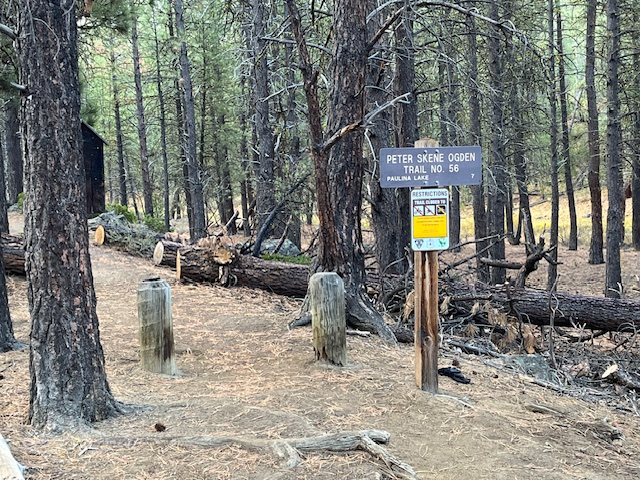 There's nothing quite like fall in Central Oregon—the crisp air, golden larches, and that quiet sense of calm before winter settles in. This past weekend, we set out on one of the region's most beautiful hikes: the Peter Skene Ogden Trail, a forested path that winds along Paulina Creek between La Pine and Paulina Lake.
A Trail Rich in Scenery and History
Named after early explorer Peter Skene Ogden, this trail follows the rushing waters of Paulina Creek through towering pines and volcanic rock formations. The moment you step onto the trailhead, you're greeted by the earthy scent of pine needles and the muffled sound of water tumbling in the distance—nature's invitation to slow down and explore.
Autumn Colors in Full Glow
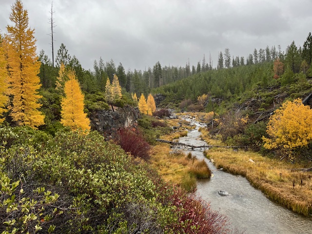
Mid-October is a spectacular time to visit. The larches were glowing gold, willows and huckleberries added bright pops of red, and the forest floor was carpeted in amber needles. Even under a soft drizzle, the landscape shimmered with color—proof that Oregon's magic isn't reserved for sunny days.
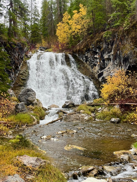
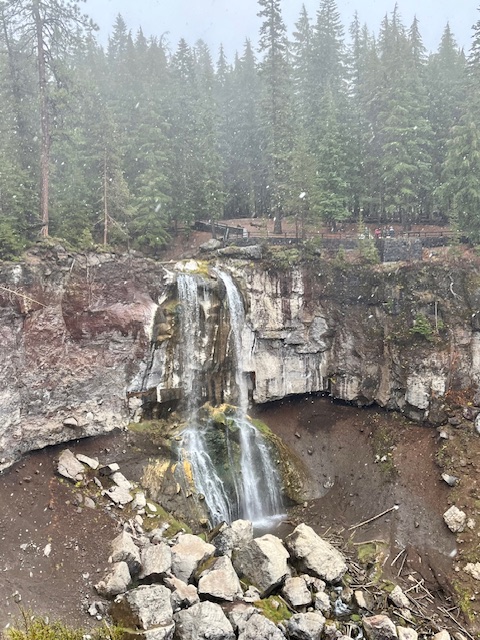
Waterfalls Around Every Bend
One of the highlights of the Peter Skene Ogden Trail is its string of waterfalls—each with its own character. Hikers can stop at several along the way:
- Lower Falls, where a broad curtain of water cascades dramatically over basalt cliffs.
- Paulina Creek Falls, a show-stopping finale that plunges nearly 80 feet into a rocky amphitheater below.
- And several smaller falls and pools in between, perfect for photos or a quiet break beside the creek.
 |
 |
Wooden bridges cross the stream at various points, offering postcard views and a chance to soak in the sound of rushing water echoing through the canyon.
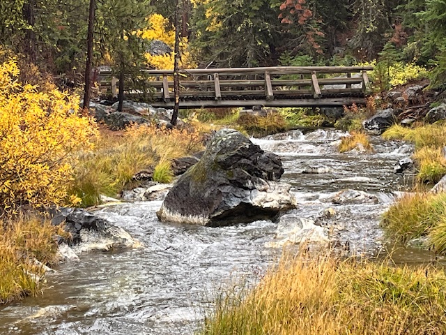 Wooden bridges cross the stream at various points, offering postcard views and a chance to soak in the sound of rushing water echoing through the canyon.
A True Central Oregon Gem
Whether you're a local looking for a quick escape or a visitor exploring beyond Bend, the Peter Skene Ogden Trail is a reminder of why we live here. It's less crowded than many popular Bend hikes, offers easy access to multiple waterfalls, and provides an ever-changing landscape from season to season.
If You Go
- Trailhead: Near McKay Crossing Campground (about 7 miles east of La Pine).
- Length: Roughly 7 miles one way to Paulina Lake, but you can hike shorter sections for a beautiful day trip.
- Best Season: Late spring through fall; expect snow at higher elevations by November.
- Tip: Bring layers, waterproof shoes, and a camera—you'll want to capture every turn of this gorgeous trail.
Why We Love Exploring Local Trails
Part of what makes Central Oregon special isn't just its homes and neighborhoods—it's the lifestyle that surrounds them. From mountain trails and alpine lakes to charming downtowns and cozy coffee shops, life here invites balance, adventure, and connection to nature.
8
Bend Premier Real Estate | October 2025 Newsletter
What's in the October 2025 Bend Premier Newsletter?
- Lower Mortgage Rates are Making a Difference
- Pumpkin Pancakes
- Get Spooky While Saving: Budget-Friendly Halloween Decor Ideas
- Carl Lake is a Little Known Hike
- 3 Advantages of Buying a Newly Built Home Today
3
Hike to Carl Lake and Beyond in Oregon's Mt Jefferson Wilderness
The Hike to Carl Lake is Little Known
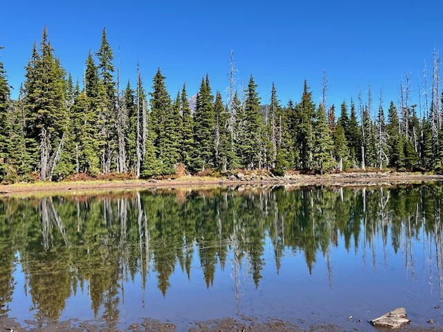
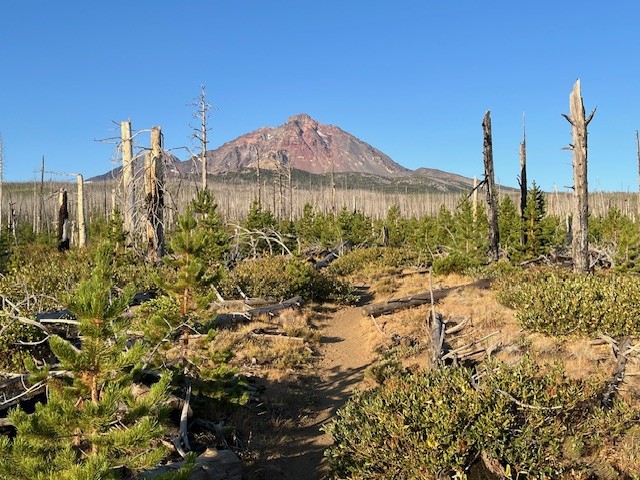
Many in Central Oregon know of the hike to Three Fingered Jack via Canyon Meadow. This trailhead to this hike is accessed from Jack Lake which is at the end of Forest Service Road 1234 in the Mt Jefferson Wilderness. Forest Service Road 1234 splits off Forest Service Road 1230 roughly two miles off paved Jack Lake Road. If instead of turning on 1234 to the Jack Lake Trailhead, people wanting a different experience can continue on 1230 for seven miles to reach the Cabot Lake (Carl Lake) trailhead (the last two miles of this road is rough).
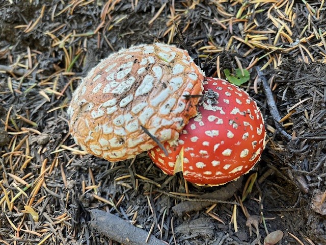
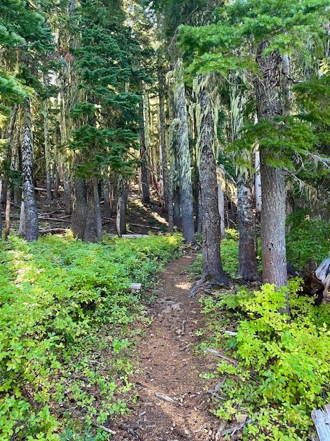
The first mile and a half of this hike is through the recovering burned forest of the B & B complex fire of 2003, but after that, the hike is in old growth forest. Two miles in the trail passes an overgrown and uncleared spur that can take hikers to Cabot Lake, a lovely forest lake. The trail has numerous blueberry bushes and in the fall, interesting mushrooms. After a series of switchbacks climbing a ridge, the trail levels out and passes three small unnamed lakes until at five miles the trail reaches Carl Lake.
 |
 |
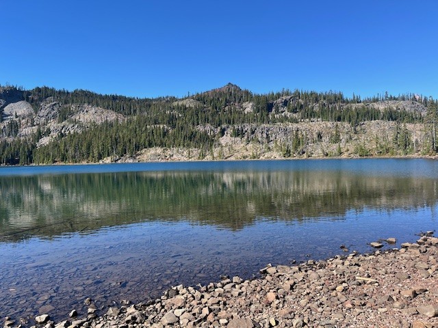
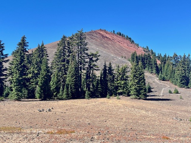
Carl Lake is a lovely, deep blue, glaciated, trout filled alpine lake. There are also many camping spots dotted around the lake for those who wish to spend some time enjoying the area. For those wishing more hiking challenges, past the south side of the lake is a trail that goes to Shirley Lake and beyond it, climbs to reach the Pacific Crest Trail. Two tenths of a mile south on the PCT is a spur trail trail west that hikers can use to summit South Cinder Cone. For those who do, the views toward Mt. Jefferson to the north and Three Fingered Jack to the south are truly outstanding.
 |
 |
Day hikers can enjoy the entire trip from the trailhead up South Cinder Cone and back in 14.28 miles and see very few if any people.
 |
 |
22
Hayden Glacier Hike on Middle Sister is a Challenge
Take the Climbers' Trail to Reach Hayden Glacier
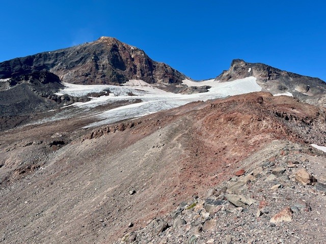
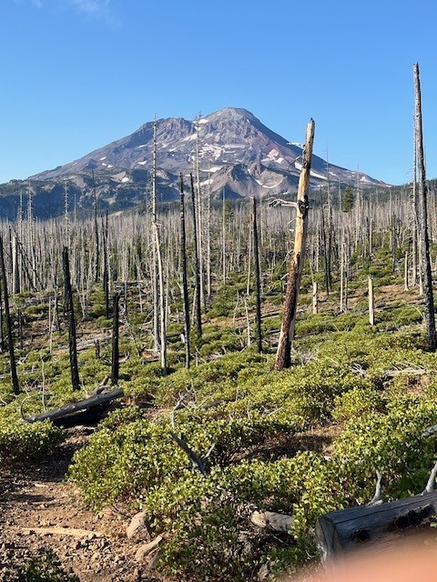
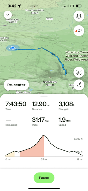
For Central Oregon hikers looking for something different that does not require a paid permit, the climbers' trail on Middle Sister is well worth it. Most hikers would start in the burned forest at the Pole Creek Trailhead located off forest service road 15 outside of Sisters (the parking at the trailhead requires $5 payment or a forest pass). After hiking the trail to the junction with Green Lakes Trail 17, trekkers continue on Trail 17 toward Park Meadow. Shortly after crossing Soap Creek is the junction with Camp Lake which hikers should take to reach the unmarked junction with the Climbers' Trail. If hikers miss this trail, it loops with another section of the Camp Lake trail near one of the branches of Wychus Creek which hikers to Camp Lake have to cross. Climbers don't cross the creek, but instead hike upstream toward Middle Sister.
Regardless of the looped trail route chosen, they join on the moraine just under Hayden Glacier. Both are steep, difficult hikes with loose pumice and boulders to traverse. For those who plan on summiting Middle or North Sister, Hayden Glacier is just another geological feature to pass by before the summiting. For those not wishing to go further, the Cascade views from the glacier are amazing.
For those starting at the Pole Creek Trailhead and hiking to the glacier but no further, plan on a full day, climbing over 3100 feet and roughly 13 miles.
 |
 |
 |
 |
10
Bend Premier Real Estate | September 2025 Newsletter
What's in the September 2025 Bend Premier Newsletter?
- It's a Mixed Market for Bend Home Sales
- Butternut Squash Soup
- Why September is the Best Month to Paint Your Home's Exterior
- Jefferson Park Has Had 2 Fires in 8 Years
- What You Need to Know About Concessions
Privacy Policy / DMCA Notice / ADA Accessibility