

Posts with tag 'Central Oregon Hikes'
Subscribe and receive email notifications of new blog posts.
 RSS Feed
7
Bend Premier Real Estate | November 2025 Newsletter
What's in the November 2025 Bend Premier Newsletter?
- A Cooler Fall Market Emerges for Bend Home Sales
- Cranberry Orange Bread
- Preparing Your Home for Thanksgiving: Cleaning and Decorating Tips
- Fall Adventure on the Peter Skene Ogden Trail
- Top 5 Reasons to Hire a Real Estate Agent When You Sell
5
Should You Sell Before the Holidays or Wait Until Next Year?
As the holidays approach, many Bend homeowners find themselves asking the same question: Should I list my home now or wait until after the New Year?
The truth is, there's no one-size-fits-all answer—but there are compelling reasons to consider making your move before the year ends.
Why Selling Before the Holidays Can Work in Your Favor
- Motivated Buyers Are Still Looking
Not everyone slows down for the season. Many buyers in Bend are relocating for work, making year-end moves to take advantage of tax benefits, or finally finding time to focus on their home search during the holidays. These buyers are serious—and they're often ready to make strong offers. - Less Competition Means More Attention
Inventory in
30
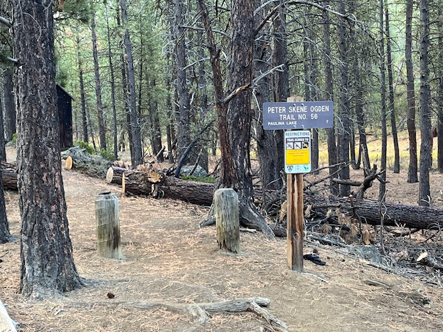
Fall Adventure on the Peter Skene Ogden Trail
Discovering Central Oregon's Hidden Waterfalls and Autumn Magic
There's nothing quite like fall in Central Oregon—the crisp air, golden larches, and that quiet sense of calm before winter settles in. This past weekend, we set out on one of the region's most beautiful hikes: the Peter Skene Ogden Trail, a forested path that winds along Paulina Creek between La Pine and Paulina Lake.
 There's nothing quite like fall in Central Oregon—the crisp air, golden larches, and that quiet sense of calm before winter settles in. This past weekend, we set out on one of the region's most beautiful hikes: the Peter Skene Ogden Trail, a forested path that winds along Paulina Creek between La Pine and Paulina Lake.
A Trail Rich in Scenery and History
Named after early explorer Peter Skene Ogden, this trail follows the rushing waters of Paulina Creek through towering pines and volcanic rock formations. The moment you step onto the trailhead, you're greeted by the earthy scent of pine needles and the muffled sound of water tumbling in the distance—nature's invitation to slow down and explore.
Autumn Colors in Full Glow
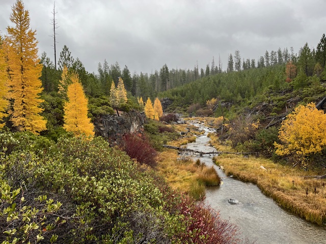
Mid-October is a spectacular time to visit. The larches were glowing gold, willows and huckleberries added bright pops of red, and the forest floor was carpeted in amber needles. Even under a soft drizzle, the landscape shimmered with color—proof that Oregon's magic isn't reserved for sunny days.
Waterfalls Around Every Bend
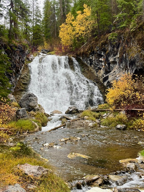
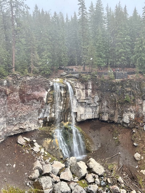
One of the highlights of the Peter Skene Ogden Trail is its string of waterfalls—each with its own character. Hikers can stop at several along the way:
- Lower Falls, where a broad curtain of water cascades dramatically over basalt cliffs.
- Paulina Creek Falls, a show-stopping finale that plunges nearly 80 feet into a rocky amphitheater below.
- And several smaller falls and pools in between, perfect for photos or a quiet break beside the creek.
 |
 |
Wooden bridges cross the stream at various points, offering postcard views and a chance to soak in the sound of rushing water echoing through the canyon.
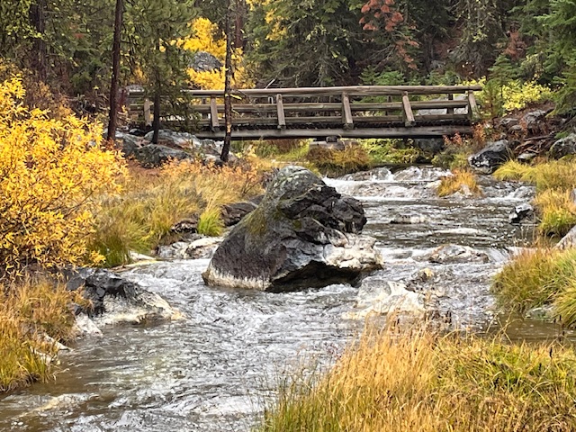 Wooden bridges cross the stream at various points, offering postcard views and a chance to soak in the sound of rushing water echoing through the canyon.
A True Central Oregon Gem
Whether you're a local looking for a quick escape or a visitor exploring beyond Bend, the Peter Skene Ogden Trail is a reminder of why we live here. It's less crowded than many popular Bend hikes, offers easy access to multiple waterfalls, and provides an ever-changing landscape from season to season.
If You Go
- Trailhead: Near McKay Crossing Campground (about 7 miles east of La Pine).
- Length: Roughly 7 miles one way to Paulina Lake, but you can hike shorter sections for a beautiful day trip.
- Best Season: Late spring through fall; expect snow at higher elevations by November.
- Tip: Bring layers, waterproof shoes, and a camera—you'll want to capture every turn of this gorgeous trail.
Why We Love Exploring Local Trails
Part of what makes Central Oregon special isn't just its homes and neighborhoods—it's the lifestyle that surrounds them. From mountain trails and alpine lakes to charming downtowns and cozy coffee shops, life here invites balance, adventure, and connection to nature.
21
A Perfect Day in Bend: How Locals Spend Their Weekend
Experience the Bend lifestyle through the eyes of those who call it home. From sunrise coffee and mountain views to riverside adventures and craft cocktails downtown, a weekend in Bend is about living fully — outdoors, connected, and inspired.
Morning: Coffee, Sunshine, and River Trails
 Bend mornings start early — not out of obligation, but out of excitement. The light over the Cascades is too beautiful to sleep through, and the smell of fresh-roasted coffee from local cafés is irresistible. Grab a morning latte at Sparrow Bakery, where locals linger ov...
8
Bend Premier Real Estate | October 2025 Newsletter
What's in the October 2025 Bend Premier Newsletter?
- Lower Mortgage Rates are Making a Difference
- Pumpkin Pancakes
- Get Spooky While Saving: Budget-Friendly Halloween Decor Ideas
- Carl Lake is a Little Known Hike
- 3 Advantages of Buying a Newly Built Home Today
Privacy Policy / DMCA Notice / ADA Accessibility